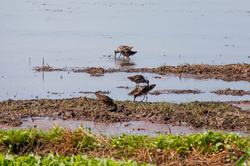
 Dowitchers in a flooded field.
 "Hear that?" said Rodd, as a buzzing in the distance came closer and then passed by, audibly, over our heads.
"That was a boat".
No, we weren't in a submarine. We were standing at the edge of a corn field about 60 miles inland from the Pacific Ocean, in an area of the central valley known as the California Delta: a complex and mind-blowing feat of engineering where dykes and dirt levees direct millions of gallons of water from the once meandering Sacramento and San Joaquin rivers into dirt-walled irrigation and flood management systems. The water from this system feeds the San Francisco Bay estuary, irrigates the land that produces half of the United States' produce, supplies fresh water for over twenty million people, and is vital for native fisheries. But the levees, which have been in place since the 1930s, are at once an awe-inspiring and terrifying web of water that literally surround us.
I was out on my first field trip to a California farm in late August with Rodd, my practitioner mentor, and Laura. Both work for The Nature Conservancy on really amazing projects with farmers to give the hundreds of millions of migratory birds that pass through the central valley on their trip along the Pacific Flyway a chance to perch, roost, wade, and feed in the vast farmscape of this area.
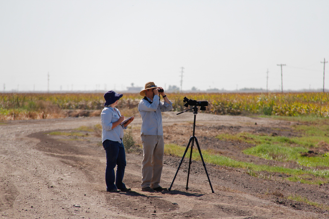
Laura and Rodd counting shorebirds
Laura and Rodd were scoping out a few new fields to add to an ongoing trial, which is being run by the Migratory Bird Conservation Partnership (a collaboration between Audubon California, Point Blue Conservation Science & TNC) to see what benefit flooding fields will have for migrating shore birds, and were kind enough to invite me along for a glimpse of the delta and to brush up on my bird identification skills. Many shore birds rely on the availability of areas of shallow water for their winter migrations, either as they head further south or as their full-time homes for the winter. There are already ongoing projects to encourage farmers to flood rice fields for longer than normal periods of time (more on rice in future posts), but this project is focusing on flooding sections of any crop fields for the early migrants that need to stop in late summer and fall.
We drove across an arching bridge over a canal to reach the farm we were visiting for the day. Underneath us, power boats zoomed up and down the channel, and further upstream a huge ship sat at port. We followed the road along the top of the levee, a canal of water just below us on our left, and a large 'island' of farmland about 35 feet below us on the right. Yes, the farmland is 35 feet BELOW the water here. It's also 15 feet below sea level. I don't know of any other islands in the world that are entirely below sea level. (In my mind, an island usually sits above sea level. That's kind of the point of islands). These 'islands' are so low because the incredibly fertile, peaty soil of the delta compacts very easily. It's also easy to imagine a lot of it blowing away: puffs of fine soil floated into the air around our feet as Rodd and I walked across one field to put stakes in the ground that will be used to judge the depth of water once the area is flooded. The soil looked and felt like ash, and my sneakers are still turning my socks grey from all of the fine dirt that I collected in them.
We drove across an arching bridge over a canal to reach the farm we were visiting for the day. Underneath us, power boats zoomed up and down the channel, and further upstream a huge ship sat at port. We followed the road along the top of the levee, a canal of water just below us on our left, and a large 'island' of farmland about 35 feet below us on the right. Yes, the farmland is 35 feet BELOW the water here. It's also 15 feet below sea level. I don't know of any other islands in the world that are entirely below sea level. (In my mind, an island usually sits above sea level. That's kind of the point of islands). These 'islands' are so low because the incredibly fertile, peaty soil of the delta compacts very easily. It's also easy to imagine a lot of it blowing away: puffs of fine soil floated into the air around our feet as Rodd and I walked across one field to put stakes in the ground that will be used to judge the depth of water once the area is flooded. The soil looked and felt like ash, and my sneakers are still turning my socks grey from all of the fine dirt that I collected in them.
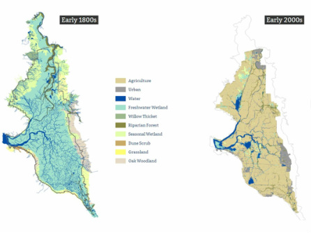
Delta habitat in the early 1800s compared to the early 2000s. Source: KCED Quest
Out in the fields that had already been flooded, there were a LOT of birds. Yellowlegs, Western sandpipers, least sandpipers, a grumpy great blue heron, Canada geese, mallards, dowitchers and killdeer to name a few. I learned a little about the fine art of distinguishing between Western and least sandpipers- which is not easy to do since the main distinguishing feature is that least's have yellowy-grey legs and western's have black legs, but when the birds are running around in mud, they all just have mud-colored legs. Then it comes down to bill length in relation to their heads and differences in moult patterns. Small sandpipers like these two are commonly called 'peeps' by the birding folks- a name which is just perfect for these dainty, fidgety, high pitched little birds. Last week, I was able to put to use my 'peep' ID skills on a Smith Fellows trip to the Central Coast of British Columbia (to be mentioned in an upcoming post).
The change that this land has undergone in the past two hundred years is probably one of the most dramatic anywhere. Where we now see vast stretches of agricultural fields cut by straight and narrow waterways, there was once a myriad of convoluted water that meandered across the valley on its way to the bay and the sea. Changes to the landscape are huge and were often undertaken without a real understanding of what the consequences might be. Dredging channels in the 1890s to make shipping between Sacramento, Stockton and San Francisco easier led to a massive change in the system: tides that once fluctuated by 2 feet or less near the inland cities suddenly shifted to 3 to 5 foot tides- leaving some ships stuck on muddy flats where once they could have moved freely throughout the day regardless of tides.
I definitely have a lot of learning to do about the Delta and the many forces (some opposing, some collaborating) working to make this system a safe, wildlife friendly, farming mecca. There are needs and opportunities for each area to improve, and I'm sure I'll hear a lot more about this huge topic over the next couple of years.
Learn more...
The maps above are from a brilliant site by KQED Quest and the San Francisco Estuary Institute called 'California's deadlocked delta: interactive map'. It is indeed full of interactive maps that can be explored to visualize the huge changes that this land has had over the past 200 years. There are also great stories from the unique history of the region that give you a feel for it- I love the part about writer William Wright getting lost after a duck hunting expedition and having to use the wings from his trophies to try and make a waterproof bed in an inch of freezing cold water when they decided they were too lost to keep floundering around in the dark and to settle in for the night.
I also found this video and article from UC Berkeley's media center a very useful starting point for understanding the engineering and importance of the Delta
 RSS Feed
